2. Published Data
The data described below represents building outlines data openly available on the LINZ Data Service (LDS): https://data.linz.govt.nz/layer/101290-nz-building-outlines/
2.1. Data Model
To assist you in understanding these datasets, the structure and details of the data fields is described in tables below. The relationship between tables and directly related datasets is provided in a data model diagram
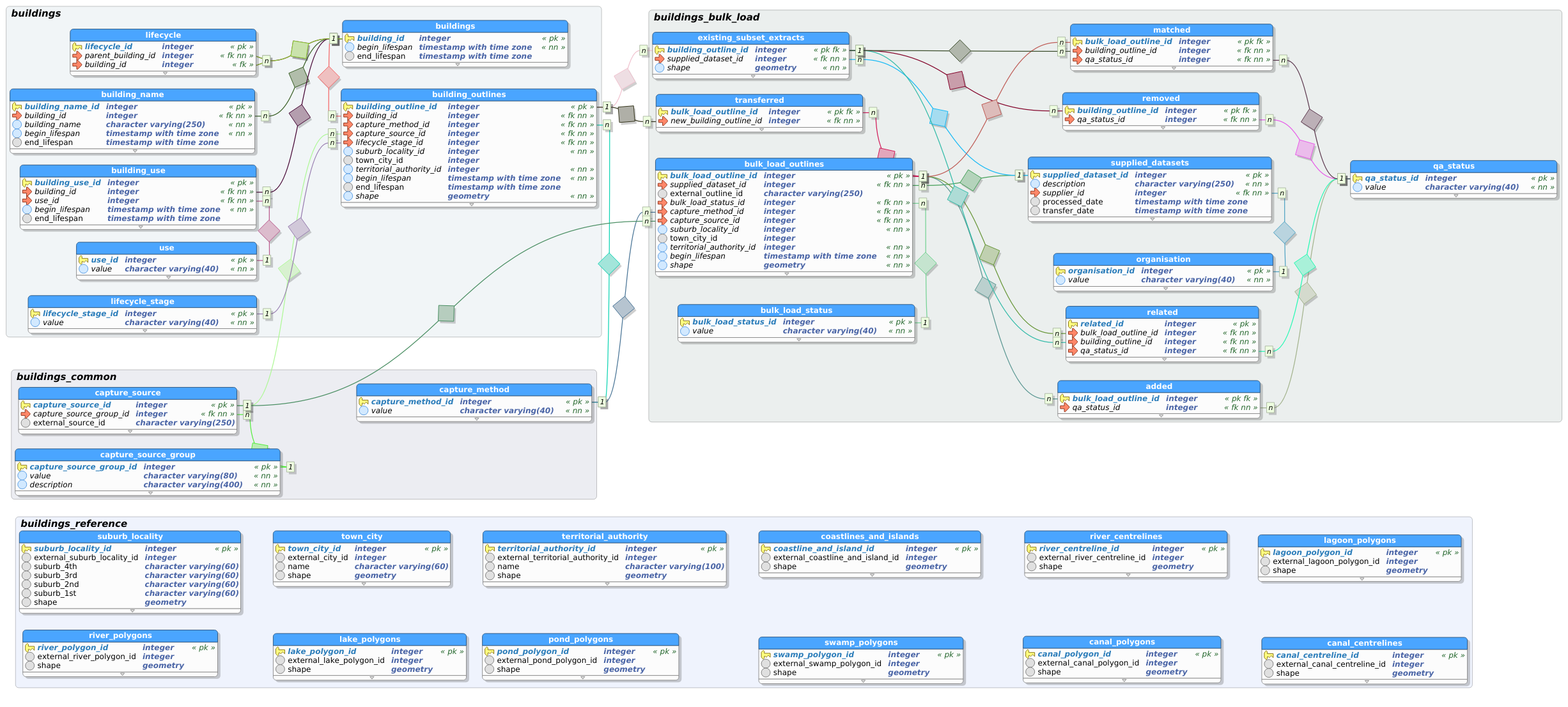
To enable changes between updates to be recorded and then queried using using LDS changesets, every table has a primary key. Primary keys in tables are shown by a field name with bold font.
2.2. Schema: buildings_lds
Description: Schema that holds tables published via the LINZ Data Service.
2.2.1. Table: nz_building_outlines
Description: NZ Building Outlines contains the most recent representation of each building as a building outline.
Column Name
Data Type
Length
Precision
Scale
Allows Nulls
Description
building_id
integer
32
No
Unique identifier for a building. The building id is persistant for the same building across all of the building outlines that represent it.
name
varchar
250
No
The name of the building where known. If no known name this will be an empty string.
use
varchar
40
No
The building use maintained for the Topo50 map series. If no known use this will default to Unknown.
suburb_locality
varchar
80
No
The suburb / locality that the majority of the building outline is within. Sourced from NZ Localities (an NZ Fire Service owned dataset).
town_city
varchar
80
No
The town / city that the majority of the building outline is within. Sourced from NZ Localities (an NZ Fire Service owned dataset).
territorial_authority
varchar
100
No
The territorial authority that the majority of the building outline is within. Sourced from Stats NZ.
capture_method
varchar
40
No
The method by which the geometry was captured e.g. Feature Extraction.
capture_source_group
varchar
80
No
The source from which the geometry was captured e.g. NZ Aerial Imagery.
capture_source_id
integer
32
No
The id of the capture source area - currently all ids are a foreign key to the NZ Imagery Surveys dataset.
capture_source_name
varchar
100
No
The title/name of the specific capture source area.
capture_source_from
date
No
The earliest date on which aerial photographs were taken as part of the related imagery survey.
capture_source_to
date
No
The latest date on which aerial photographs were taken as part of the related imagery survey.
last_modified
date
Yes
The most recent date on which any attribute or geometry that is part of the building outline was modified.
shape
geometry
Yes
The geometry of the building outline represented as a Polygon using NZTM2000 / EPSG 2193. Internal rings are possible multiple external rings are not.
2.2.2. Table: nz_building_outlines_all_sources
Description: NZ Building Outlines: All Sources contains all combinations of outline / building / name / use that have existed within the building outlines system, and the dates for which that combination existed.
Column Name
Data Type
Length
Precision
Scale
Allows Nulls
Description
building_outline_id
integer
32
No
Unique identifier for the building outline. The building outline id is unique to one representation of a building.
building_id
integer
32
No
Unique identifier for a building. The building id is persistant for the same building across all of the building outlines that represent it.
name
varchar
250
No
The name of the building where known.
use
varchar
40
No
The building use maintained for the Topo50 map series.
suburb_locality
varchar
80
No
The suburb / locality that the majority of the building outline is within. Sourced from NZ Localities (an NZ Fire Service owned dataset).
town_city
varchar
80
No
The town / city that the majority of the building outline is within. Sourced from NZ Localities (an NZ Fire Service owned dataset).
territorial_authority
varchar
100
No
The territorial authority that the majority of the building outline is within. Sourced from Stats NZ.
capture_method
varchar
40
No
The method by which the geometry was captured e.g. Feature Extraction.
capture_source_group
varchar
80
No
The source from which the geometry was captured e.g. NZ Aerial Imagery.
capture_source_id
integer
32
No
The id of the capture source area - currently all ids are a foreign key to the NZ Imagery Surveys dataset.
capture_source_name
varchar
100
No
capture_source_from
date
No
capture_source_to
date
No
building_outline_lifecycle
varchar
40
No
The lifecycle of the building outline. Lifecycles with an end_lifespan date may either be “Removed” (new aerial imagery shows no evidence of the building) “Replaced” (a new building outline exists captured from new aerial imagery) or “Recombined” (new building outlines exist captured from new aerial imagery but in an m:n relationship). Lifecycle relates to the status of the building outline only. See nz_building_outlines_lifecycle to determine recombined building relationships.
begin_lifespan
date
No
The date the building outline was added to NZ Building Outlines database.
end_lifespan
date
Yes
The date the building outline was removed replaced or recombined within the NZ Building Outlines database.
last_modified
date
No
shape
geometry
Yes
The geometry of the building outline represented as a polygon using NZTM2000 / EPSG 2193. Internal rings are possible multiple external rings are not.
2.2.3. Table: nz_building_outlines_lifecycle
Description: The lifecycle table stores the relationship between buildings when one building is split into two buildings or two buildings are merged into one building. This will generally occur when a building outline was erroneously captured encompassing two buildings, which later becomes clear with additional aerial imagery.
Column Name
Data Type
Length
Precision
Scale
Allows Nulls
Description
lifecycle_id
integer
32
No
Unique identifier for a lifecycle.
parent_building_id
integer
32
No
Foreign key to the buildings_lds.nz_building_outlines_all_sources table. All records stored as parent buildings will have a date in building_end_lifespan.
building_id
integer
32
No
Foreign key to the buildings_lds.nz_building_outlines_all_sources table. This is the child in the relationship - (one of) the building(s) that replaced the parent building.